 Colorado! You know where it is; it’s one of those square northern states that doesn’t quite border Texas. What’s the first thing that comes to mind when you hear Colorado? Mountains? The city of Denver? Something else? Before I went there, that was about the extent of my knowledge on the state. But during a five day camping trip I took this summer, I learned there are many more things to do in Colorado than just climb mountains.
Now, Colorado is not an extremely large state (It has an area about half that of Texas) nor does it have a very large population (5 million to Texas’ 28). But what it does have is mountains: lots of them. And I know I just said there is more to do there than the mountains, but the magnitude of them is worthy of note. Colorado has over 20 mountains taller than 14,000 feet. For some more context, the tallest peak in Texas is about 8,750 feet tall. In the winter time, these mountains draw skiers, but in the summer, they draw hikers.
Our crew consisted of eight boys and two adult leaders from Boy Scout Troop 28. The original plan was to go backpacking at Philmont Scout Ranch in northern New Mexico, but our trek was cancelled due to forest fires. Instead of just taking our refunded money and staying home, we went on our own trip. We set off in late July, and although we did make a few stops along the way, Colorado was definitely the main attraction.
Our first destination in the state was the Great Sand Dunes National Park and Preserve, only about 50 miles north of the New Mexican border. On the drive in, we got to see some of the legendary 14,000 foot tall mountains surrounding us as we slowly gained elevation. In Colorado, even if you’re not on top of a mountain, you still have quite an elevation. The Great Sand Dunes National park is about 7,500 feet above sea level, and Austin is only 600 or so. Anyway, it was dark when we arrived at the park so we couldn’t actually see the dunes, but could vaguely see the enormous mountains silhouetted against the fading light of the sunset. In fact, when I first saw them, I thought they were huge clouds hanging above the horizon.
Arriving at the campsite at the park we were pleasantly surprised by the temperature. Back home at that time, it was probably over 80 degrees, but here it was a cool 60. We set up camp and put on jackets that hadn’t been needed in Texas since mid-March.
Next morning we got a better view of our campsite. The mountains covered with green trees were on one side, the open plains that stretched on the horizon on another side, and the sand dunes in front of us. The dunes were not in the sun yet, but we could see them for the first time, and they looked like small mountains. But as the sun began to move over them, we could clearly see that they were not covered in rocks and trees, but instead a smooth layer of sand.
After breakfast, we packed up our tents and started the short hike to the 700-foot-tall sand dunes. As we got off the paved road, the trail felt like walking on the beach, only there was no water. We were the first ones to get to the dunes that morning, so there were no footprints or any sign of human activity.
As I mentioned before, we were at an elevation of over 7,000 feet, and we gained most of that in one day, so we were all still adjusting to the lack of oxygen in the air. It’s very bizarre to look at a small hill and think, “I can run up that, no problem,” and then get totally tired out halfway up.
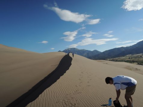
The whole way up the dunes, the views were amazing. Every direction looked totally different. Sometimes the sand had a wavy pattern, shaped by the wind, and sometimes it looked perfectly smooth. Because we went in the morning, the angle of the sun bathed one side of the sand ridge in light, while the other was in the dark shadows.
On the way down, I decided to have a little fun by finding a particularly steep area and sliding down it on my stomach. The downside was I got a little sand in my clothes. Normally that would be fine, except I had a camera and cell phone in my pocket. The phone survived fine, but my poor little Nikon didn’t make it.
After we shook as much sand out of our shoes as we could, we loaded up the van and headed north. As we gained elevation, we got to see the sand dunes from a different perspective; they looked tiny against the huge mountains behind them.
That night the plan was to stay at Monarch Pass Campground, about 100 miles north of the Sand Dunes. When we pulled into our campsite in the mid afternoon, it was raining, an event we would be all too familiar with before this trip was done. After the rain stopped, we set up our tents on the soggy ground and got ready for dinner. Most dinners we would eat in Colorado were trail meals, consisting of granola, energy bars and freeze-dried food. Tonight it was slightly green mac and cheese and spicy Planters peanut mix. It was much colder than the previous night, so we started a campfire to keep warm.
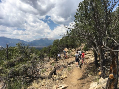
Our activity for the next day was mountain biking, so we broke camp and headed to the small town of Buena Vista, about 45 minutes away. One interesting thing I noticed about these small Colorado towns is that the city limit signs say the elevation of the town, not the population. So when we got to Buena Vista, it said “Elevation 7,965” instead of “Population 2,778.”
We had a nice early afternoon of mountain biking, and got some help navigating the trail from a friendly Colombian man who happened to be biking there at the same time as us. We left Buena Vista and headed back into the mountains for our camping spot that night, Mount Princeton Campground. Along the way, we saw the Mount Princeton Hot Springs, and all agreed we should plan to make a stop there later on in the trip.
Like the previous night, our campsite had beautiful views of the tree covered mountains, and a mountain stream nearby. The evening was mostly uneventful, except when one of the guys accidentally put trail mix in the soup instead of dried vegetables.
The next day, the plan was to head back to Buena Vista for our next adventure, whitewater rafting. At the rafting place, we got decked out with water shoes, life jackets and helmets. The rafts were loaded up on a trailer, and we all filed onto the big blue bus with several other groups. The bus driver greeted us by asking, “Is this your first time?” Only a few people said yes. “Well, don’t worry,” he said, “It’s only a bus ride.” It got a good laugh out of us.
After the short bus trip, we hopped out and met our guide, a guy named Trevor. We got our boat and headed for the water, which was already filled with rafts. Trevor explained that this was the busiest he’d ever seen the river, as well as the lowest water level. We waited our turn and then headed out. Our responsibility was just to row the boat, and Trevor did the steering, which was nice because we didn’t have to worry about navigating the river and just left that to the professional.
Riding down the river was fun, especially when we hit some rapids. Trevor told us that this was the most rafted section of river in the country, and we could see why. It was just the right amount of challenge to make it fun, but not too difficult to make it dangerous. The original plan was to get out of the river at a certain point, have lunch and get back in. Unfortunately, the dark clouds that had been looming over us had different plans. It began to hail marble-sized chunks, so they had to cancel the rest of the trip. We loaded up the bus and headed back to the raft place in town. We were a bit bummed about getting our rafting trip cut short, but we got refunded $20 per person, and the adults promised we could put it to good use.
We saw exactly what that use would be just a few miles down the road–the Mount Princeton Hot Springs, which conveniently charged $20 per person. There were a few pools of varying degrees of heat, and then the natural hot springs in the river. It was a nice spot to relax after a few days of camping, and very bizarre to be walking in a cold river and suddenly find a spot of 100 degree water.
That night, we had to ask some help from the locals to find a spot to camp, and they pointed us to a place called Bootleg. This campsite was different from the others because it wasn’t a national park, but an open area along a trail. It was about 100 yards from the parking lot, so we cooked dinner down there and carried our gear up to the campsite. It was a bit more rugged of a camping place, which was god practice for our next activity.
The next day we headed for Browns Lake Trail, where we would start our legit backpacking trek. The plan was to leave whatever we didn’t absolutely need in the van, and carry everything else on our backs. The trail to the lake was six miles and had two thousand feet of elevation, so we had a bit of a hike ahead of us.
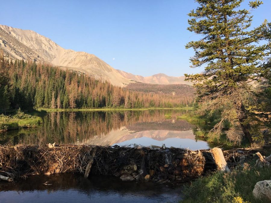
We all had different hiking experience, so our crew was a little spaced out on the trail. It was a tough hike, as it was mostly all up hill. We all persevered, and made it there in a mostly timely manner. When we crested the last hill, we were greeted by Browns Lake and a very cold breeze. We threw off our packs and pulled out our jackets, and waited for the rest of the crew to arrive. The only two campsites on that side of the lake were taken, so we set up camp in the meadow nearby.
When we started hiking it had been sunny, but as we made our way up the mountain the clouds began to roll in. At the camp it was completely overcast, and we all feared it was going to rain. Unfortunately, we were right. Not long after we set up our tents, it began to pour. We set up a dining-fly-type contraption so we could cook dinner and be sort of dry. Being wet and cold at the same time is not only uncomfortable, it can be very dangerous. Catching hypothermia can be very easy in this situation. Dinner was freeze-dried beef stroganoff, which may not sound overly appealing, but huddled under a tarp in the rain in what had to be 40 degrees, it tasted pretty good.
The rain stopped eventually, and we had the task of putting up a bear bag. When camping far away from civilization like we were, it is necessary to put all food in a place where the wildlife, especially bears, can’t get to it. We found a suitable tree, threw a rope over a branch, and hoisted the bags up. After that, we called it a night. There was no dry wood for a fire, so the sleeping bag was really the only warm place.
We were happy to see the sun the next day, as it meant no more rain, for the time being. One of the groups occupying a campsite was leaving, and they let us have their spot. It was much nicer than the meadow, and there was some protection from the wind plus a fire pit. So we carried the set up tents a few dozen yards to the new area. We didn’t do much that day, just played cards on a table we found at another campsite. At one point, one of the adults went for a swim in the lake, which he described as “pretty cold.”
A few of us went on a day hike even higher up the mountain. On our hike, we really got a feeling for how high up we were. About a hundred feet above us was the tree line, which is an altitude at which trees can no longer grow due to lack of moisture and oxygen and is usually at about 12,000 feet. We also saw meadows with a surprising amount of wildflowers.
For dinner we had more delicious freeze-dried meals (today it was gumbo) and started a campfire. The wood had time to dry, so we could keep ourselves warm that night with a fire. We hung up the bear bags, and got ready for bed. We would have to hike back down the mountain the next day, so getting up early was necessary.
We got started at about 6 a.m. the next day, and the meadow was covered in fog. It looked like we were in a cloud. We took down camp and headed back for civilization. The hike down was much less challenging than the hike up because it was mostly downhill. We made it back to the base of the trail and drove back to Buena Vista. The goal for that day was to drive to Santa Fe and spend the night at a campground we had reserved outside of the city. During the hike down, one of the guys said his side was hurting, so his dad (who was luckily one of the adults on the trip) wanted to take him to a doctors office before we hit the road again. While he went to the doctors’, the rest of the gang got some ice cream and went to tourist shops. We waited an hour or so, and learned that he had appendicitis and had to stay at the hospital for the night. Lucky for him the doctors said he should be able to leave the next day.
The rest of us went back to Bootleg campground, where we stayed before the six mile hike. The next day we picked up our now appendix-less friend, and headed south for New Mexico. We had spent a total of five days in Colorado, but it felt a lot longer than that. We didn’t have any dull days, from the sand dunes to the mountain biking to the white water rafting and then a six-mile hike followed by one of the guys getting minor surgery. Even if we didn’t do any skiing or go to Denver, it felt like we got a pretty full Colorado experience.


